| Official name: | Democratic Socialist Republic of Sri Lanka |
| Government type: | Republic |
| Location: | Latitude 5° 55. to 9° 50. north, longitude 79° 42. to 81° 52., 650km north of the equator |
| Dimensions: | 430km north to south, 225km east to west |
| Coastline: | 1,340km |
| Area: | 65,525km |
| Currency (code): | Sri Lankan rupee (LKR) |
| Independence: | 4 February 1948 |
| Administrative capital: | Sri Jayewardenepura |
| Commercial capital: | Colombo |
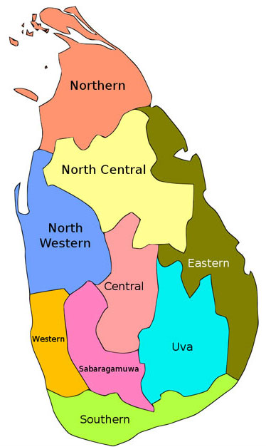
| Administrative divisions: | 9 provinces; Central, North Central, North Eastern, North Western, Sabaragamuwa, Southern, Uva, Western, Eastern Province. |
| Climate: | Typically tropical, with a northeast monsoon (December to March) bringing unsettled weather to the north and east, and a southwest monsoon (June to October) bringing bad weather to the south and west |
| Terrain: | Mostly low, flat to rolling plain; mountains in south-central interior |
| Highest mountain: | Pidurutalagala, 2,524m |
| Highest waterfall: | Bambarakanda, 263m |
| National Flower | The Blue Water Lily (Nymphaeastellata). |
| National parks and nature reserves area: | 8,000sq.km |
| Population: | 21,128,773 (? Census) |
| Population growth rate: | 1.3% |
| Languages: | Sinhala (official and national language) 74%, Tamil (national language) 18%, other 8% Note: English (a link language commonly) is used in government and spoken competently by about 10% of the population |
| Religion: | Buddhist 69.1%, Muslim 7.6%, Hindu 7.1%, Christian 6.2%, unspecified 10% (2001 census) |
| Time zone: | Sri Lanka Standard Time is five and a half hours ahead of GMT. (Allowance should be made for summer-time changes in Europe.) |
| International dialing: | +94 |
| Electricity: | 230 . 240 volts, 50 cycles AC. If you travel with a laptop computer bring a stabilizer |
| Highest Mountain: | Pidurutalagala, 2,524m |
| Highest Waterfall: | Bambarakanda, 263m |
| National Flower: | The Blue Water Lily (Nymphaeastellata) |
| National Parks and Nature Reserves Area: | 8,000sq.km |